
Advancements in weather modeling and satellite communication continue to make sailing across oceans faster and safer. Both computer-driven weather routing apps and human routing professionals can now easily deliver sophisticated weather intel to any boat anywhere on the planet. Because of this, most offshore sailors today don’t hope for good weather; they aim for it instead.
Fantastic routing advice, coupled with snappy graphics, can lead a sailor to believe that crossing oceans is as simple as crossing the street. Unfortunately, modern technology does not provide a passage panacea. No weather router is going to be able to find you an easy ride eastbound across the North Atlantic in January. Understanding routing guidance advice—and knowing when to follow it and when to question it—will help a navigator make the most of this valuable resource.
Don’t put the rudder before the sail.
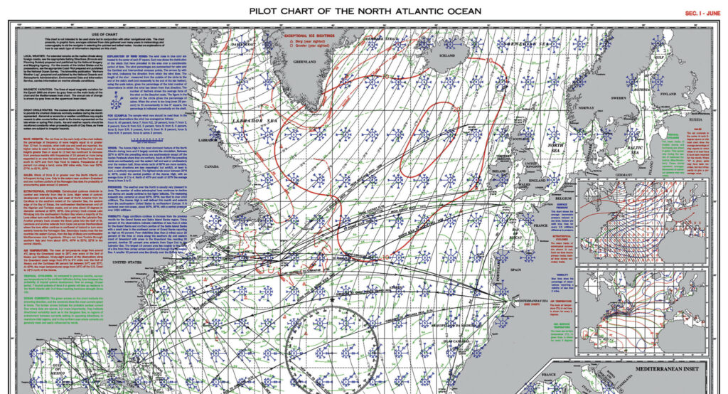
Before studying the weather, know the climate. Smart voyage planning still starts with an analysis of the pilot charts that detail historic average monthly weather conditions—i.e., climate—for any relevant sections of ocean. All offshore passages will still be sailed most easily in the optimum season.
The NGA, a U.S. government agency, produces free pilot charts compiled from historic weather observations covering all oceans. Oceanographer, sailor, and writer Jimmy Cornell has produced his own atlas of pilot charts utilizing satellite observations. Although not available for free, the Cornell pilot charts are considered by most to be a superior and up-to-date resource. In a companion text titled World Cruising Routes, Cornell goes on to apply this data by detailing optimum seasons and routes for most common ocean passages. A careful study of these resources is an important first step at the outset of any voyage planning.
Traditional seamanship skills still play a part in prudent passage planning. Even top-notch weather routing will fail to skirt every storm. The crew and boat still need to be prepared for rough weather. If comms go down offshore, a passage may need to be completed with yesterday’s toolbox of skills. Observation of clouds, bird behavior, and ocean swell patterns can still help a competent navigator avoid bad weather and make a safe landfall. It’s smart to consider historic weather patterns and build some sea room into a route should the boat need to heave to or run before a storm. For a smooth arrival, the prudent navigator should still sail for a point slightly upwind of the destination. Good seamanship is just as relevant now as it was a hundred years ago.
Once the broad strokes of route and timing have been established, it eventually comes time to shove off. At this point, instead of thinking about the climate history of yesteryear, it’s time to focus on the weather of today and tomorrow.
Weather routing services help offshore sailors avoid storms and calms to complete ocean passages as quickly and safely as possible. When data on a boat’s sailing capabilities (known as “boat polars”) are cross referenced against an accurate weather forecast, human and computer-driven weather routers can produce customized sailing directions that should yield an optimal route for any passage.
It’s great to have an abundance of weather information when selecting an exact departure date and when navigating along the miles of a passage. A sailor can gain important confidence when weather models align and when professional meteorologists confirm a passage plan. At the same time, an essential part of the captain’s job is to consider all available information and avoid fixating on any single source. The lived experience of being onboard is one important data point that the boat crew has and the weather router lacks. It would be folly for a captain to relinquish control over a course steered to someone or something that isn’t onboard.
The prudent navigator will digest weather routing directions as advice worthy of consideration and not as a mandated course that the boat must steer from point A to point B. To get the most out of any routing service, it’s important to understand their limitations and be willing to ignore recommendations when a fault is seen in the logic or when the sea state has the crew feeling uncomfortable aboard in real life.
The prudent mariner will keep a weather eye out for the following four types of guidance frailties:
1. The need for speed.
It’s hard to strike the right balance between speed and onboard comfort from afar.
On a recent passage from Bermuda to the Azores, we were advised by computer algorithms and by a human pro to work our way 100 miles north of the rhumb line to an area of ocean where we could make 7.5 knots of speed in 25-30 knot winds and rain. Instead, we opted to stay on the rhumb line, where we happily made 6.5 knots of speed in a 15-knot wind on the beam and the sun overhead. My wife and I prefer to sail in 15 knots of wind rather than 25-30. That’s just us and our personal preference. We also know that 25-30 can easily escalate to 35-40 when the weather model is a tad bit off. Eventually, we’d need to work our way north to try to avoid the prevalent calms west of the Azores, but we could do that later. And we did.
On my intake interview forms, I told the human and computer routers that we would be willing to sail in 25-30 knot winds if needed, so they didn’t think twice about putting us in those conditions when they anticipated it to be the faster route to sail. There was no question on those forms asking me if I would prefer to dodge some rain and sail in more moderate wind and sea conditions for a one knot speed penalty tax. That sort of important nuance is missing from the process.
Every sailor wants to sail efficiently, and every sailor wants to sail fast. But at what cost? If we had been racing, we would have been compelled to sail toward the stronger wind to remain competitive. But on this passage, we were squarely in a cruising gear, and top speed wasn’t our priority.
At the outset of this passage, we’d departed Bermuda at approximately the same time as five other boats bound for the Azores. Thanks to Starlink and my stalker tendencies, I was able to watch on long-range AIS as all five of the other boats sailed north into the stronger wind. I could visualize the thought bubble above the heads of the captains of these boats: “The pros know a lot more about weather than I do, so I should do what they say. After all, that’s why I paid for this app subscription and/or this human weather routing pro. Besides, the traditional sailing route on the passage calls for me to sail north out of Bermuda to get up into the westerlies and avoid calms towards the end of the leg, so this sounds right.” It was easy logic to follow, but upon debriefing in the Azores a few weeks later, the sailors I tracked down agreed that, if they had it to do over, they would have made a different choice.
As an aside, the calm patch in the Azores High just west of the archipelago was vast enough to trap all of us in no-wind conditions for several days at the tail end of this passage, regardless of the route we opted for in the early stages out of Bermuda.

2. Comfortable sailing is hard to define.
Optimizing sail trim for comfort, both in high wind and low wind, can be delicate work. Offshore sailing guru John Kretschmer explains, “Every boat has its own discussion with apparent wind.” Sometimes you need to prioritize what your boat is telling you she needs today over where your weather router is telling you to steer for tomorrow.
The placid Azores High provides another example: Winds were light at the start of our onward passage from San Miguel up to the Isles of Scilly. The advice I was given was to sail north and east to find stronger pressure. Once again, the human pro and my weather routing app were in agreement on this particular directive. The problem was that when we sailed on the prescribed course, progress was slow and our sails were slatting in the rolly sea state. To keep the boat moving and to keep the sails quiet, we needed to turn to the west by about 40 degrees to heat up our wind angle. This course alteration meant we were sailing more toward Greenland than toward England, but the sails weren’t tattering themselves to shreds, and the boat was sailing comfortably, allowing Alex and me to get the off-watch rest we needed.
I got some pushback from my human router cautioning me about not following orders and sailing in the wrong direction. Our boat polars showed that we should have been able to make good progress sailing on the prescribed course with the available wind, so I understood the router’s confusion about our course steered. The relevant detail that was hard to model was the boat’s roll in residual swell from a low-pressure system long since passed. The sea state was glaringly obvious to us on the boat, but unseeable to those back at the weather routing command center, wherever that might be.
On our boat, when Alex comes on watch and looks around, she’ll often be heard saying, “Oh, we’re going 6 knots. Nice.” And then, after a pause, a skeptical scowl will come across her face, and she’ll ask, “Are we pointing at it?”
“No, we’re not pointing at it,” I’ll sometimes confess. “But we’re going 6 knots, so who cares?!”
The wind shifted as it always does, and eventually, we managed to point the bow in the right direction. Our track up to Scilly might have looked silly at times, but we got there.
Steering off course on passage can get you into trouble. Enduring tough sailing to keep the boat and crew away from even tougher sailing is often required. Other times, veering off course for a while can make life aboard far more comfortable and only costs a minor delay on arrival.
In hindsight, on this passage, it was smart to aim for a smooth ride. It didn’t matter much that our course, at times, was poorly aligned with our destination or our routing instructions. At sea, the roads are loosely defined, and it’s often okay to drive on the shoulder if it feels good.
3. Computer algorithms and human weather routers trust their long-range forecasts. You shouldn’t.
Weather routing directives often drag you surprisingly far away from the traditional sailing route in search of a bit of helpful breeze seen days ahead and in a long-range forecast. If that favorable wind fails to materialize, you can find that you have sailed many extra miles out of your way for no good reason.
Driving on the shoulder is one thing, but taking a ridiculous detour for no good reason is just never fun. The savvy captain will be cautious about straying too far from traditional sailing routes in search of favorable weather, especially if that favorable weather is far away and plagued by all the uncertainties that always accompany long-range forecasts. In this aspect, voyaging can be like racing, where staying in the middle of the course, and away from the lay-lines is usually a smart play, because it gives you options further up the leg.
When considering a deviation from traditional sailing routes offshore, it’s important to consider the motivation. If you are sailing off your line to avoid a serious storm, there’s a lot of reward to be gained for not much risk. Whereas sailing out of your way for a slight improvement in anticipated sailing conditions days ahead is a far less compelling motivator.
4. Currents mess up everything.
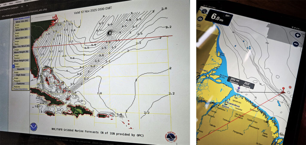
Ocean currents are complex and poorly understood. Computer algorithms and human weather routers don’t have good data on currents, and they don’t know what they don’t know. Surprisingly, near-coastal currents remain local knowledge. They aren’t well tabulated online, and they are not readily accessible to weather routers. Out in mid-ocean, currents are chaotic, constantly shifting, and largely unpredictable at this point in the history of science. When an unexpected delta between a boat’s speed over ground and speed through the water presents, she strays away from her anticipated position, and model errors compound quickly as a result.
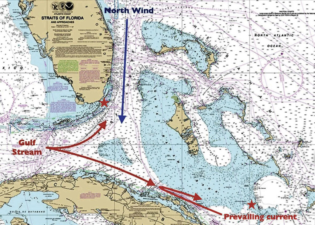
I’ve found myself surprised by currents many times. In one such instance, we were sailing from the Ragged Islands in the Bahamas to Key Largo via the Old Bahama Channel along the north coast of Cuba. The models on my weather apps all agreed that sailing should be good along our route. (I hadn’t consulted a human pro for this one, and perhaps I should have.) A cold front accompanied by a strong north wind had just crossed over Florida and the Bahamas. Our plan was to ride the tail end of this north wind down towards Cuba; by the time we turned west into the Old Bahama Channel, the wind was scheduled to clock around to the southeast and send us sailing blissfully downwind towards Florida. That same southeast wind would have plenty of time to settle down the Gulf Stream before we reached those waters.
I expected a favorable current in the Old Bahama Channel that would merge into a favorable Gulf Stream current as we approached Florida. I understood these currents to be reliable and never-ending, like gravity. But I was wrong. It turns out that a strong north wind can cause the Gulf Stream to split around Cay Sal Bank, sending a powerful surge of Gulf water down along the north coast of Cuba, effectively reversing the prevailing current in the Old Bahama Channel. The effect only lasts for a few days, but it’s real and reliable—kind of like gravity, you might say. I lacked the local knowledge to anticipate this change in current flow. The computer algorithm driving my weather router app also lacked data on this quirky phenomenon and was ill-prepared to provide me with reliable routing advice on this route.
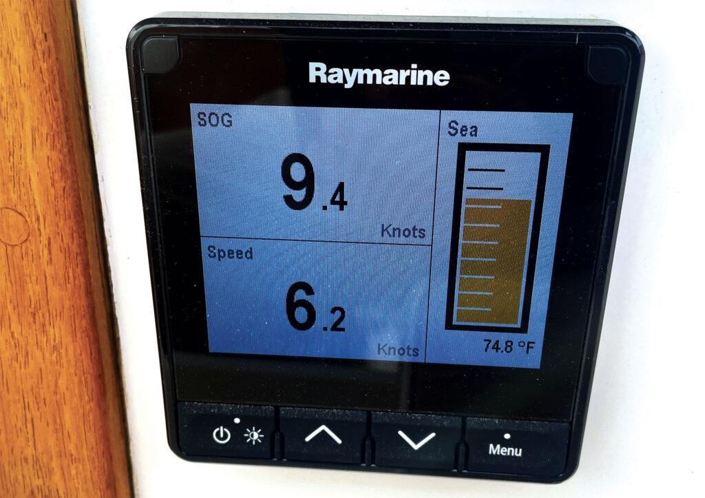
I had expected our 6-knot speed through the water to be boosted by current to 8 knots over ground. Instead, the adverse current slowed us to a 4-knot crawl. It was like someone switched the direction on an airport corridor moving walkway. Those 200 miles in the Old Bahama Channel lasted forever. Sliding north onto the Bahama Bank got us out of the worst of the adverse current, but it was still a slog. We also now had wind against current, making for an uncomfortable sea state. Salt in the face and salt in the wound.
I’ve seen mid-ocean, color-coded current maps that look like a messy head of curly hair in need of a hairbrush. It begs credulity. Could this really be the way currents work out there in the middle of the ocean? If so, no wonder no one can make an accurate forecast. Aside from the broad outlines of the major world currents, it looks completely unpredictable.
I guess the weather routers figure that favorable current will cancel adverse current over time and can just be ignored. This might be true over a lifetime, but not often during any single trip.
Takeaways
I’m a fan of modern weather routing services. They’ve provided me with helpful information on hundreds of short and long passages, and I suspect they will continue to play an important role in my sailing going forward. I also know that the better I’ve come to understand the capabilities and weaknesses of these services, the better suited I am to utilize the information they provide.
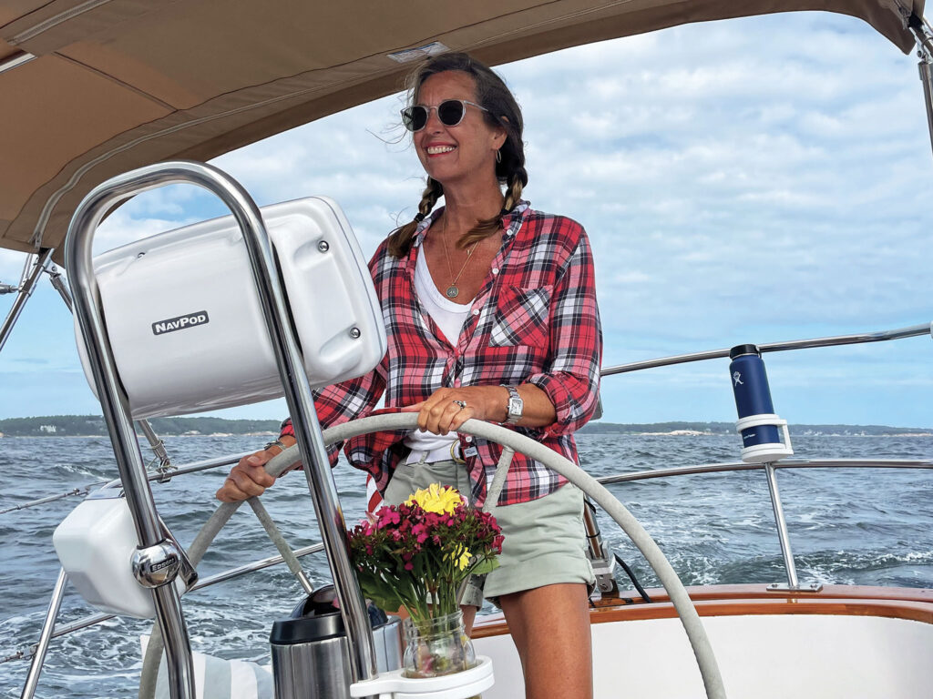
SAIL Contributing Editor Christopher Birch is the founder of Birch Marine Inc. in Boston. Chris and his wife, Alex, are now cruising full-time aboard their 36’ Morris Justine. Follow their voyage at www.EagleSevenSailing.com
January/February 2026


")


