
My first time crossing the Gulf Stream we blew up a spinnaker in extraordinary fashion: power-reaching in a short-period sea state, comfortably into double digit boat speeds…It’s fair to say we exceeded the structural limits of the fabric. I don’t recall there being a single panel left intact, and recovering the scraps was an all-hands-on-deck exercise on this 60-footer.
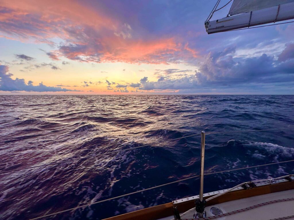
My most recent Gulf Stream reunion brought about a similar wind angle, albeit with a bit less waterline. We were powered up but with smooth water and an enchanting night sky. If we hadn’t glanced at our instruments, we almost wouldn’t have known we were in the Stream at all—the change in warmth and humidity was subtle and largely lagged our entry. It was one of the smoothest crossings I’ve experienced. This time around as we started fighting an even tighter angle, we doused the spinnaker before it suffered a similar fate to the previous one.
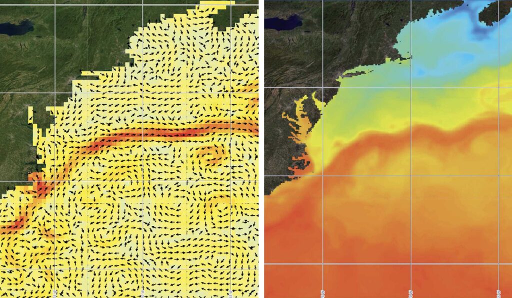
composite charts show similar Gulf Stream paths in differing detail. Chart from NOAA
In between these events, every other Gulf Stream crossing or ride has carried some sort of peculiarity. It adds to the mysteriousness of this natural wonder and encourages plenty of scrutiny in navigational decisions. I’ve spent a day and a half becalmed, spinning in an eddy on the edge of it. Another encounter had me living in squalls the entire way across. One time, the current seemed near non-existent and maxed out around 1.7 knots—I’m still wondering if we found a way around it altogether. Sadly, I’ve also logged friends losing their boat in the Gulf Stream.
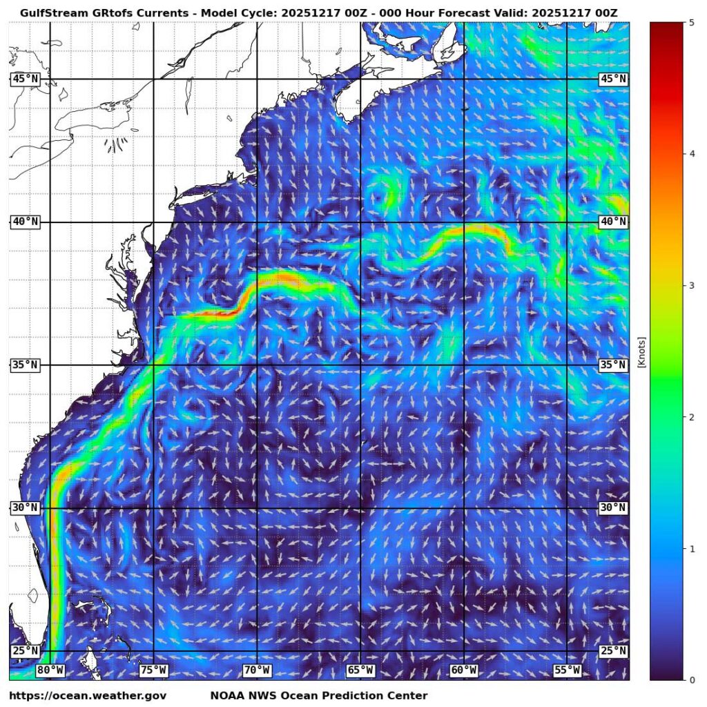
When sailing from the Bahamas or Florida to New England, riding this feature for as long as possible carries an advantage. In other cases, the goal is to get across it as quickly as possible. The strong current, topping out around five knots (but most frequently observed as a three to four knot peak for a Bermuda Race), is often not pulling in a beneficial direction.

It also carries its own micro-climate and conditions can change rapidly. When the wind opposes the current, waves stack up and make, at the very least, an uncomfortable experience, if not a dangerous one. Especially if cruising, it may be worth delaying entry in such situations. The warm, humid air brews squalls that call for quick sail plan adjustments and foul weather gear at the ready. Lines of clouds are common, especially at the edges, but the Stream is not necessarily characterized by that phenomenon. Even the temperature and Stream position will vary seasonally.
The Gulf Stream is part of a larger ocean current system known as the North Atlantic Gyre. The easterly equatorial trade winds and the mid-latitude Westerlies combine with further Coriolis effects (from the earth’s rotation) to form a network of clockwise rotating surface currents. The continents establish the boundaries, with the eastern coast of the United States forcing the intensified current of the Gulf Stream. Meanwhile, the evaporative heat loss of the warm Gulf Stream increases the Stream’s salinity (and density) as it travels north and east and becomes the North Atlantic Drift. A portion splits off as the Canary Current while the rest continues northward, eventually becoming cold and dense enough to sink below surrounding waters. This forms a thermohaline circulation (a current driven by temperature and salinity differences) where deep slow currents return this water towards the tropics.
From a sailor’s perspective, this is simpler than what we experience. Enter meanders and eddies. The 20 to 100nm wide Gulf Stream (at least off the coast of the U.S.) is far from a smooth arc, particularly as the fast-moving current turns eastward and leaves the confines of the coast. In open water, the Stream becomes unstable, like the swirling clouds rising from a hot drink, persuaded by variations in wind, water density, flow velocity, and sea floor topography. The bends in the Stream are referred to as meanders; they get as extreme as doubling back on themselves, resulting in that section of the Gulf Stream getting pinched off and forming an eddy (a circulation of current that breaks off the main current and travels independently) that can last for months and has typical diameters in the 60 to 185 nautical mile range.
These eddies present themselves on both sides of the Stream, with warm-core rings rotating clockwise (the result of a northern or western meander) and cold-core rings rotating counterclockwise (the result of a southern or eastern meander). Smaller eddies can also form on the edges due to velocity shear. In all cases, Gulf Stream eddies tend to migrate to the southwest.
The Gulf Stream’s local patterns are constantly evolving; every crossing or ride will be different. Our best tools for predicting the flow are based on extrapolating observations. Satellites capture water surface temperatures and altimetry.
The Gulf Stream is noticeably warmer than the surrounding waters. In a typical Newport or Marion to Bermuda Race, expect to see temperatures in the high 70’s to low 80’s, but note that the temperature varies with time of year and recent weather systems. Regardless, there is an observable temperature differential between the Stream and surrounding waters. Infrared satellite imagery defines the stream and helps visualize the eddies through surface temperature. The issue with this approach is that it’s only available on clear days: clouds block the technology from working otherwise. Days, sometimes weeks, pass without getting a complete view of the Gulf Stream. Multiple images can be combined to form a dated composite, with a series needed to understand trends. Using the infrared method, current velocity is best estimated using sequential infrared imagery and comparing the movement of unique features along the flow of the stream or eddy.
Altimeter satellites take a different approach by mapping the height of the ocean using radar and laser technology that can penetrate cloud cover. Measurements are accurate to about an inch, which is adequate to determine Gulf Stream features (after correcting for atmospheric pressure and tide). Higher sea levels are associated with the Gulf Stream and warm eddies, while lower sea levels are coupled with colder features. Flow is modeled moving parallel to contours of equal height with magnitude a function of the pressure gradient and Coriolis force. NOAA updates these maps multiple times a day, but the satellite used for this data collection takes approximately 10 days to complete a full global scan: this means data is an average of five days old.
For the most accurate predictions, it’s worth reviewing published maps from both technologies and observing changes over a period of months (resources: coastwatch.noaa.gov and ocean.weather.gov). Observations from other boats or NOAA’s Global Drifter Program can be insightful, but they better serve other purposes, lacking the timely full picture clarity we need for optimal routing.
Charting an advantageous course then requires some level of cooperation from the wind. The best solution for a passage or race will not necessarily favor the current, nor the wind, but will be a combination of factors that create our multi-dimensional problem, different for every boat. There will always be some missing information, but with more accessible data offshore, routing can be continuously updated to match the latest forecasts. But be prepared for conditions to vary from expectations—forecasts are just best guesses after all.
Observations are grounded in reality. We can use them to validate or correct a game plan, or even understand which forecast model is trending as the most accurate. Well before approaching the Gulf Stream, monitor water temperature, SOG (speed over ground) versus boat speed, COG (course over ground) versus heading, and cloud patterns. Keep an eye on the water color. Well offshore, the Gulf Stream is frequently a striking clear and vibrant cobalt blue (though storms and biological activity can change this). Sea state, especially wave period, is another helpful data point. Each tells part of the story and helps to build the full picture. Although tempting, don’t let the Gulf Stream and eddies distract from wind observations too.
Recall that Gulf Stream strategy ties closely to the wind forecast, and with that, where we desire to be when we exit. Furthermore, depending on the meanders of the stream, hitting the eddies correctly can be even more important than the Stream itself due to their size (they can be just as strong as the Stream itself, though they’re not typically), and this applies to both sides of the Gulf Stream. We plot our desired entry and exit points every time and often add additional waypoints for eddies.
Sometimes maximizing the benefit from one eddy may mean adverse current from another. Fall back to a high-level strategy to analyze these contradictions. Depending on the performance level of the boat, it may not be worth varying far beyond the rhumb line, unless the wind forces it. Significant extra distance sailed is challenging to overcome by a current boost, plus there is the uncertainty factor with chasing currents. When in doubt, run the numbers and walk through the tradeoffs.
Ultimately, we’re placing educated bets when making these navigational decisions. There will be disappointments and welcome surprises, but it is all in how we adapt to the challenges that determine our success and experiences. The Gulf Stream is just one aspect of a passage in this part of the Atlantic, but undoubtedly a fascinating one.
This article was originally published in the March 2026 issue.


")


