

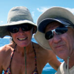
My husband, Neil, and I had left Mexico in March on board Distant Drummer, our Liberty 458 sloop, with a plan to spend the rest of the year on a leisurely cruise down the west coast of Central America. It was in this way that, after enjoying the delights of El Salvador and Nicaragua, we arrived in Costa Rica in mid-May where we were looking forward to exploring the coast and visiting several of the national parks.
The west coast of Costa Rica can be split into three parts. Golfo de Papagallo in the north is exposed to the Pacific swell, but the rocky coastline has several sheltered anchorages and some great surf spots. Golfo de Nicoya in Central Costa Rica is an excellent cruising ground with a myriad of beautiful bays and islands protected behind the Nicoya Peninsula. The southern region of Golfo Dulce has only a handful of anchorages, but is wild and remote, with amazing wildlife in several outstanding national parks.
The three months we spent cruising on Costa Rica’s Pacific coast seeing the beauty of its shoreline and the fantastic diversity of its flora and fauna was a remarkable and memorable experience.

Golfo de Papagallo
During the winter the Golfo de Papagallo is prone to strong northeasterly “Papagallo” winds caused by the easterly trades from the Caribbean funneling through low points in the Central America mountains. These offshore winds create rough conditions off the coast and picking a gap between them is a primary consideration when transiting this area. When we left Nicaragua bound for Playas del Coco in Costa Rica, no papagallos were forecast, and we enjoyed an easy reach across Bahia Salinas in a light easterly breeze. As we rounded the ragged rocky point of Cabo Santa Elena the wind then dropped in the lee of the cape, and we motorsailed past the jagged teeth of the Murcielagos Islands.
The horseshoe-shaped bay of Playas del Coco is a sheltered anchorage guarded by a reef to the west and by Punta Cacique and the Islas Pelonas to the north. It is the northern port of entry for Costa Rica, so we went ashore to complete the customs and immigration formalities, stopping first at the office of the port captain in a faded blue building near the beach to register our arrival. Then we went to the immigration office, which was close by, then back to the port captain for more paper shuffling before taking a bus ride to the customs office located at Liberia airport. By mid-afternoon we were back in Playas del Coco, passports stamped and clutching our three-month cruising permit, the maximum length of stay permitted in Costa Rica.
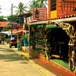
The Golfo de Papagallo, also known as the Gold Coast, is a popular spot for tourists. The towns, therefore, have well-stocked supermarkets, ATMs and casinos (the best place to get good Wi-Fi). Away from the gringo beaches, there are plenty of remote islands and empty bays, which we promptly set about exploring.
The nearby Bahia Culebra, for example, has half a dozen tranquil coves, each rimmed with an arc of golden sand fringed with rainforest and dotted with the occasional coconut palm. Under Costa Rican law, no buildings of any kind can be constructed within 50 meters of the high tide mark, with the resulting space designated as public land. As a result, the coastline is uncluttered, preserving the unspoiled beauty of the natural shore, where we enjoyed many balmy evenings listening to howler monkeys high in the canopy inland. At dusk the gruff bark of the alpha males echoes across the bay, sounding primal and exotic.
Northwest of Playas del Coco, the Murcielagos (or “Bat”) Islands are part of the Santa Rosa National Park and completely undeveloped. We anchored in a truly idyllic bay at the eastern end of the island chain in super-clear aquamarine water, warmed to a pleasant 84 degrees by the brilliant sunshine, and had great fun snorkeling on the rocky reef with colorful and inquisitive fish darting all around us. There is a ranger station in the bay and boats are required to pay a fee to anchor; however in the three days we were there we waved to the rangers, but they did not approach the boat.

With strong offshore winds and a rolling southern swell, the Gold Coast is a natural draw for surfers, but the anchorages can be uncomfortable, as the rollers tend to drive straight in. Fortunately, we found a reprieve when we dropped the pick for a night behind Ollie’s Point so that Neil could surf Ollie’s, a well-known point break on the other side of the bay. Just north of the bay is the airstrip from which Oliver North supported the Nicaraguan Contras via illegal arms sales to Iran in 1986—the surf break was named after him.
Back in Playas del Coco, we provisioned for the passage south to Golfo de Nicoya. This should have been made easier by the fact that water in Costa Rica is potable and was readily available at taps behind the beach. However, with a breaking surf and 9ft tides, getting the water on board was a bit of a workout. We chose high water to avoid a long haul across the beach, and while I held the dinghy out beyond the surf line Neil lugged jerry cans through the waves and heaved them on board. Repeat eight times and bingo—our water tanks were full!
Stretching away to the south and east, the Nicoya Peninsula is open to the Pacific swell and the few bays along the western shore where it is possible to anchor on the 100-mile passage round to the Golfo de Nicoya are often rolly and uncomfortable. Nonetheless, we decided to make the voyage in day hops rather than sail at night and run the risk of getting entangled in any fishing nets.
At the end of our first day out, we motorsailed to Tamarindo (or “Tamagringo,” as the locals sometimes call it) in a drizzle and light northwesterly. The rain continued the next day, but the breeze picked up and we had a soggy starboard reach down to Samara. The bay at Samara is protected by reefs that extend from both sides almost closing off the entrance. We entered cautiously at low tide and found a spot deep enough to drop the pick. At high tide, though, as the swell pounded in across the reef it proved rolly.
Lightning is a constant fear in the wet season in the tropics, and in Samara, we experienced a terrific storm. As the first drops of rain splattered on the deck we turned off the power, unplugged the computers and put all our essential electronics (GPS, phones, VHF) into the oven in the hope of protecting them from a lightning strike. We lay in bed watching as dazzling forks of lightning illuminated the clouds, followed by earsplitting cracks of thunder. We tried counting the seconds between the two, but they were almost simultaneous. Eventually, the storm moved on. The rain, though, didn’t stop all day.

Golfo de Nicoya
Our first stop in the Golfo de Nicoya was Montezuma, at the southern end of the Nicoya Peninsula. It was not a great anchorage as it is open to the southerly swell. But the small town is picturesque with a laid-back arty beach culture. Known locally as “Montefuma,” the village offers yoga at dawn and nuts and seeds for breakfast, followed by some uplifting herbs sold by a local neo-rasta—it was a great place to relax for a day or two. The hike to the waterfall there follows a river through the rainforest, where the myriad tones of green, the drone of the cicadas and the cool chill of the falls itself brought back memories of Borneo and the Marquesas.
Bahia Ballena is a short distance to the north of Montezuma is a favorite anchorage for cruisers passing through Costa Rica as well as for boats planning to explore the Golfo de Nicoya. We anchored on the southern side of the bay close to a fishing village and threaded our dinghy between pangas and a spiders web of mooring lines to tie up at the concrete jetty. A walk along the dirt track through lush rainforest led us to a deserted beach where we watched the surf crashing against the rocky shore and basked in the wonderful emptiness of it all.
With a multitude of anchorages, each only a couple of hours apart, cruising on the east coast of the Nicoya Peninsula is relatively simple and straightforward. However, strong tides stream in and out of the gulf and hops between the islands must be planned with the tide tables close at hand. Currents up to 5 knots, for example, flow around the bony finger of Islas Negritos, creating turbulent water at the point. As we sailed up to the small town of Paquera we raced past on a flood tide, taking care to give the rocks a wide berth.
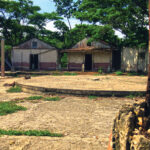
After a quick stop to provision in Paquera, we headed to Isla San Lucas, where we planned to explore the remains of an old prison. Originally a penal colony in the 16th century, the island then served as Costa Rica’s Alcatraz until it was finally abandoned in 1991. On arrival at the dock, a ball and chain was apparently manacled to the ankle of each prisoner, which proved to be an effective method for preventing escape.
The prison, although deserted, is open to visitors so we kayaked ashore to explore the old buildings; seven cell blocks that once held around 700 inmates, ringing a semicircular courtyard. It was fascinating to look at the graffiti on the cell blocks: much of the drawings featured religious images or naked women, as well as a host of other things that the prisoners were longing for.
Puntarenas is the largest town in the Golfo de Nicoya and was developed in the early 19th century for the export of coffee to Chile and later to Europe. Coffee was first grown in Costa Rica in the 1700’s and thrived in the rich volcanic soil and cool high altitudes of the Central Valley. However, after a new port was built at nearby Caldera to accommodate larger modern vessels, Puntarenas fell into decline and is now home to the Gulf’s fishing fleet.
No great surprise given its name, the town is built on a sand spit and is not an easy place to anchor, as the sheltered north shore is shallow with a meandering channels and sand bars. At high tide we used a pilot to guide us up to the Costa Rica Yacht Club, getting through with just a few inches under the keel. We then tied up to the floating dock there, where we were assured there was adequate water for Distant Drummer’s 6ft draft. A quick look at the depth and tidal range revealed the error in that statement. But by then it was too late and we were already starting to sink into the mud at low tide, eventually finding ourselves heeled over a good 10 degrees to starboard and having to watch out that our rigging did not get tangled with that of the adjacent boat.
After topping off both our provisions and our propane tanks, we departed for Golfo Dulce to the southeast. The sunlit sail down the Golfo de Nicoya in a light southeasterly breeze was heavenly, with butterflies fluttering around the boat. That night we anchored at Herradura, a pretty crescent-shaped bay at the entrance to the gulf, after which the wind veered and we had a brisk 20 knots right on the nose for our passage to Quepos.
Manuel Antonio, our next stop, is both the smallest and the most famous park in Costa Rica. After obtaining an anchoring permit for the park in Quepos we sailed to a bay on the west side of the reserve and tucked in behind Punta Catedral, where we were sheltered from most of the swell. In the morning we walked through the park to pay the entrance fee and hired a guide to help us spot some of the weird and wonderful creatures that inhabit the park. Many of the more timid animals receded into remote parts of the forest when the gates opened, but that was when the white-faced Capuchin monkeys got active. They are natural performers, and their acrobatic antics entertained the crowd as they swung down to the paths hoping for treats and to pick a few pockets.
Golfo Dulce
With a fickle wind and a north-setting current we motorsailed most of the 50 miles from Quepos to Drake’s Bay, named after Sir Francis Drake who anchored his famous ship the Golden Hinde there in the 16th century. Interestingly, in Costa Rica the British hero is remembered only as a notorious pirate and his treasure is purportedly buried somewhere close by. Located at the northern tip of the Osa Peninsula the main attraction of Drake’s Bay is a visit to the Corcovado National Park, the biggest park in Costa Rica and, because of its inaccessibility, off the itinerary for most tourists.
Our Corcovado expedition began at some bleary-eyed hour in the morning with a panga arriving alongside Distant Drummer. Still, we dutifully climbed aboard and gradually woke up during the hour and a half ride down to Sirena, one of the ranger stations in the park. Our guide, Carlos, had worked as a research assistant at Corcovado for many years and was fantastic at identifying monkeys and birds high up in the canopy, finding tiny lizards and frogs lurking in the shadows and under leaves.
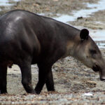
We peered at boa constrictors entwined in the bushes and glimpsed raccoon-like white-nosed coati in the dense undergrowth of the jungle then. Best of all, as we gathered to board the panga, a tapir wandered out on to the beach and grazed on the low branches of a tree for several minutes before trundling across the sand to sniff around the waterline. After that it lay down on the rocks and dozed while a tickbird (yellow-headed caracara) climbed along its back, picking off ticks one by one. We watched mesmerized as this otherwise elusive creature enjoyed its spa treatment, but finally set out again for Drake’s Bay.
Next day, the weather was squally as we sailed around the Osa Peninsula into Golfo Dulce, with a gusty southwest wind and endless rain, and we were glad to enter the protected bay at Golfito and drop anchor on the edge of the channel opposite the town. In the mid 20th century Golfito was a major banana-growing region, and the town was developed by United Brands to pick, package and export the fruit. Since the decline in the banana industry, however, Golfito is best known for its duty-free shopping centre—handy if you need a case of rum!
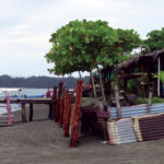
The waterfront is also dotted with marinas catering to the sports fishing industry, with an outfit called Land Sea Services providing a focal point for cruisers. For a small fee, you can tie up at the dinghy dock, use the showers, Wi-Fi or the laundry service and hang out in the clubhouse chatting to Katie and Tim who know all there is to know about the area.
Golfito is also the southern port of entry to Costa Rica, which was convenient, as it was now time for us to continue our voyage south into Panama. Cruising the Pacific coast of Costa Rica had been delightfully exotic: anchoring in jungle-clad bays with the grunting call of howler monkeys in the trees at night, sailing with beautiful butterflies fluttering around the boat and dolphins splashing in the bow wave and spotting the strange and elusive creatures that inhabit the national parks all made it a truly unique experience. As they say in Costa Rica, Pura Vida! It was an experience we will not soon forget.
Suzy Carmody and husband, Neil, are continuing their cruise down the Pacific coast of Central America on their Liberty 438 cutter, Distant Drummer
Photos courtesy of Suzy Carmody
September 2019


