
 Photo by Shutterstock
I have rarely had a cruise that wasn’t different from my expectations, and my Nova Scotia travels have borne that out. For my friend and shipmate, Steve White, and me, our 2017 trip to Cape Breton Island and the Bras d’Or Lake on One Timer, my Sabre 362, was a much anticipated return to Nova Scotia. On our previous trip, in 2009, we’d had to take shelter from two hurricanes—Bill and Danny.
Both, fortunately, tropical storms by the time they found us, followed the same path over Nova Scotia on successive weekends, a level of storm activity without precedent. The result was a lot of port time, tied to a wharf up the LeHave River in Bridgewater for Bill, and alongside the fishing boats in Woods Harbour for Danny.
What drew us back last year, more than anything else, was the warmth and generosity of the Nova Scotian people. In 2009, folks in Bridgewater came by the wharf to make sure we were OK and give us rides into town to do our shopping. In Woods Harbor, the owner of the fish processing plant drove Steve up to the Coop where you need a special card to buy diesel, filled our two jugs and then refused payment. He later invited us to use the shower in his house.
 Photo courtesy of David Short
Another friend, Chuck Bellinger, joined us for the eastbound portion of the trip, and time constraints meant we had scheduled just over three weeks for the entire cruise, although six weeks would have been ideal. Days under way were eight to 10 hours, covering 40-60 miles, until we got to Halifax.
Along the Maine coast, many cruisers get to Mt. Desert Island and go no farther. Similarly, in Nova Scotia many stick to the south shore, west of Halifax and east of Cape Sable. In both cases, however, many of the most interesting areas to explore are farther east, especially if you’re partial to less development and having anchorages to yourself. In part, it was weather that had us in this stretch longer than the others, but perhaps it was also good luck.
Our introduction to Nova Scotia’s eastern shore was in Three Fathom Harbor, about 10 miles east of Halifax. Working with 10- to 20-year-old information from our cruising guides, we nosed into this tiny port and headed for the anchorage north of the government wharf that, as explained to us later by a local, was completely silted in due to a recent project that altered the water flow. As my depth alarm sounded and the display told me we had a foot less water than my draft, we circled around and likely plowed our way back through the silty mud to tie alongside Knot-T-Boys, a halibut boat at the end of the wharf where we spent a peaceful evening.
 Illustration by Pip Hurn
The following day dawned bright and clear. The forecast northwesterly came in as a light southwesterly on our tail, and we made 48 miles, sailing wing-and-wing, to anchor above Harbor Island where we took in a beautiful sunset that was matched by the sun rising out of the North Atlantic the following morning. The next couple of bright, sunny and mostly light-wind days took us to St. Peter’s Canal, the southern entrance to Bras d’Or Lake, an inland sea in the center of Cape Breton Island. Part freshwater, part salt, the lake is over 100 miles long and connected to the Atlantic by several channels.
St. Peter’s Canal has a single tidal lock and a bascule bridge. The height differential is about 4ft 6in, depending on the tides. Passage through the quarter-mile canal is on request, as long as there is no opposing traffic en route. After locking you through, the lockmaster hops in his pickup truck and drives around to the bridge, stops traffic, swings the bridge and sends word back for you to proceed. Similarly, the Barra Straight drawbridge, between Great and Little Bras d’Or, opens on request. These bridges are on two of the three cross-island routes, but there is no hesitation to stop traffic for visiting sailors.
The water temperature had now climbed from about 55F to 68F as we progressed from the Gulf of Maine eastward along the coast to Canso, a pleasant surprise indeed. On the lake, water temperature was in the 72F range. The lack of shoreside showers proved no problem, as bathing off the transom and a freshwater rinse with the cockpit wand did the trick. At the Crammond Islands, we had to spot for one another as the red jellyfish were also enjoying the water.
Our Bras d’Or experience ranged from a flat calm on our sunny and warm first day to a sporty reach across a short while after that under a double-reefed genoa in 25-30 knots from the northwest, plowing through a short steep chop and dodging rain showers. The lake reminded me of the Finger Lakes in Upstate New York, with high hills rolling down to the water’s edge, except it was mostly forested and with fewer farms than you might expect.
Whycocomagh Bay is a western arm of the lake, into which we sailed in a 15-20 knot west wind: tacking down the bay and then returning on a downwind sleigh ride to anchor in Campbell’s Cove off the Washabuck River, watched over by a large bald eagle, the first of many.
We also observed blue herons in most of the quieter anchorages, including one in Cape George Harbor, our last stop on the lake. The latter we even saw spear some breakfast along the shore before moving up to perch high on a treetop. In addition, we saw lots of seals and a few porpoises, but only one whale on our initial trip over from Maine.
Our return home started with a visit to Whitehead Harbor, where we stayed for three days waiting out a nasty southeasterly blow before continuing on down to the Liscomb River through a still-sloppy sea. Roughly halfway along the Eastern Shore, we took refuge at the Liscomb Lodge, where we spent a windy, rainy day showering, laundering, watering, icing and fueling. The dock was small, and the two boats tied up left no room for fueling, so we anchored downriver and dinghied over the fuel and water.
The following day, with the wind still blowing and the seas kicking up, we tucked around Liscomb Point to take advantage of the Inland Passage as we headed back west. This is a 20-mile stretch among the islands, largely sheltered from the open water, which allowed our westward progress in favorable conditions with great scenery. After that, we exited the passage and crossed some open water past Taylor’s Head in the afternoon to reach Shelter Cove south of Pope’s Harbor and another great solitary anchorage. Next day we motored over large rollers in calm conditions, westward toward Halifax, enjoying a couple of hours sailing as well.
 Photo courtesy of David Short
Arriving in Halifax, the contrast from a deserted Eastern Shore anchorage to berthing at Museum Wharf downtown couldn’t have been greater. Or more fun, since we happened to be there on a Saturday night—and a warm early September one at that, so that the waterfront was alive with strollers and tourists. After a bit of a walkabout, we sat on deck eating supper from some local food vendors, occasionally chatting with passersby. Steve and Rick got sensible lobster rolls, but I had to try “donair meat,” something we first saw on the menu in Cape Breton. Consisting of shaved steak with tomatoes, onions and donair sauce, it came from a shack that specialized in poutine, a Canadian specialty involving French fries, cheese curds and gravy. It was OK, though not something I’d fly back to Halifax for. On a more positive note, our meals were all washed down with one of Nova Scotia’s better surprises, Alexander Keith’s IPA. I have yet to be tempted by poutine.
Later, Rick Chandler, our westbound crewmate, and Steve were kept awake until 0200 by the party boat tied up behind us, although I remained oblivious and slept through it all. It was all I could do to keep them from blasting the fog horn as we departed first thing the next morning.
The government’s presence on the waterfront seems to be a double-edged sword. On the one hand, even the smallest of harbors with just a few fishing boats have substantial wharves and breakwaters built and maintained by the government. The same is true of Halifax where the wharves are built and operated the government.
However, Nova Scotians are quick to point to government ineptitude, even more so than in the States. During our stop in Lunenburg, for example, one of the few harbors purporting to offer yacht services, we were looking forward to showers, a pumpout and topping up the water tanks. Then Doug at the Boat Locker, one of whose moorings we picked up for the night, explained that the government-owned showers had gone out of commission earlier that summer, two weeks before a tall-ships event and had simply been shuttered after that rather than repaired.
The dock with the pumpout and freshwater was also inaccessible because the harbor authority had rented the whole dock for the summer to a local developer with a large yacht, and he wouldn’t allow anyone else to use it. Luckily, we managed to top up our tanks from a tap outside the museum restaurant, installed by the owner for this very purpose, using our collapsible jugs.
I have also found Canadian navigation buoys curious. They vary a fair bit in size, with little apparent rhyme or reason. I find this especially interesting given that this is a coast known for fog and heavy weather that many of the cans and nuns are no bigger than a 5 gal bucket and don’t show up too well on radar. Often, they are simply not there, though marked on the light list and updated charts.
From Halifax we headed out around Sambro Head and sailed west across St. Mary’s and Mahone Bays, escaping rain showers fore and aft, to the LeHave Islands. Up the False LeHave we went and then on into Folly Channel, a tight little anchorage between Coveys and Hirtle Islands. It is situated such that it would have provided good shelter from the forecast 25-knot northwesterly blow that didn’t actually materialize while we were there. Our bug screens proved handy here as the “mossies” did not hesitate as the sun retired over Coveys Island.
Up and away by 0800, we had a great beam reach in a 15-20 knot northwesterly down to Lockeport, 50 miles away, the same place where we had cleared in on the way up, less out of the way than the more popular Shelburne, but lacking showers or dockside fuel. While there, Steve called a local service station whose owner drove down after hours, made two trips with jerrycans to fill us up and refused anything more than the cost of the fuel. Again, the best reason to visit Nova Scotia is the people.
It was here, after clearing in, that we also spent a day waiting out the weather in the company of a couple of interesting boats. The first, Androméde, a 41ft steel ketch set up for distance cruising, was being piloted by Julien, Nina and their two young children. They were Halifax-based where Julien worked as a marine biologist primarily engaged in monitoring offshore mineral extraction companies. They were headed offshore, hoping to observe some whales and prepare their kids for possible distance cruising.
The other was crewed by a pair of 20-somethings who had quit their tech jobs to get a taste of freedom while they still could. They were sailing a ‘60s vintage Cal 40, largely as originally equipped. They had spent much of the summer exploring the Maine coast, had come across to Nova Scotia a few weeks before and were now headed south. We regarded these fellows with more than a bit of jealousy.
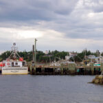
From Lockeport, we motored around Cape Sable with a clear view of the lighthouse so many never see due to fog. A favorable southwesterly then came up and carried us up to Pubnico, a crowded fishing harbor on the southwest coast, where we tied to a lobster boat with clear decks due to it being the offseason on that part of the coast. The fleets are a lot larger and more active here, as the cooler waters and the large Fundy tidal range yield bigger catches. We had a delicious supper of just-off-the-boat haddock and scallops at the Dennis Point Cafe and retired to a peaceful night.
In the morning, timing our homeward departure back across the Gulf of Maine to avoid the ubiquitous lobster traps in the dark, we watched a couple of boats unloading and sorting their haddock catch from Georges Bank. Off at 1100, we motored out through the Tusket Islands riding 4.5 knots of (fortunately) favorable Fundy tidal current. At one point we got up to 10.5 knots over the ground in the roiling waters funneling between the islands. As we came onto a course of 305 degrees for Great Duck Island, south of our home on Mt. Desert Island, the southwesterly filled in at 10 knots, giving us a close reach overnight, with the sun setting off the bow, lots of stars overhead and a crescent of moon rising off the starboard quarter at midnight.
The breeze waned at 0400, which was timely as we scraped along a couple of lobster buoys with navigable light still 90 minutes off. With the arrival of civil twilight, visibility was sufficient to fire up the Westerbeke and motor on into Blue Hill Bay, where we tied up to the Bartlett’s Landing dock at 0930 after 25 days and 1,058 miles of sailing in all kinds of conditions and meeting lots of great people.
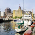
The crew enjoyed Halifax’s lively waterfront district
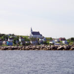
The picture-postcard town of Canso, on the easternmost end of Nova Scotia

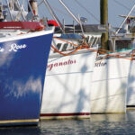
Lobster boats await the start of the season in Pubnico, on the southwest shore
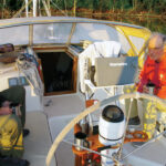
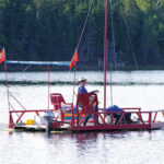
On the Bras d’Or Lake, it’s all about being on the water…
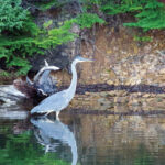
Wildlife was abundant, and not shy

Red sky at dawn… the sun rises over the Atlantic at Harbor Island on Nova Scotia’s Eastern Shore
One Timer shares a dock with the local fishing fleet in Three Fathom Harbour
CRUISE NOTES
Peter Loverridge’s Cruising Guide to Nova Scotia covers the whole coast, up through Cape Breton Island. His website is cruisingguidetons.blogspot.com from which you can order his book on a thumb drive. The original version is long out of print. He maintains a blog with updates.
Mike Cox’s Cruising the Eastern Shore covers Halifax east to Canso in significantly greater detail, and Cheryl Barr’s Cruising Guide to the Canadian Maritimes covers Cape Breton Island best. There are a few copies of Mike’s book on the used book sites and Landfall appears to have some copies of Cheryl’s book.
Cruising Cape Breton
The Pilot Press website has online user updates for their guides to Nova Scotia, Newfoundland & Labrador.
Our experience with fog on both trips was largely limited to Cape Sable upon first crossing over, corroborating the conventional wisdom that later August through early October gives the clearest weather. We had some cool evenings, but never fired up the cabin heater.
We carried two diesel jugs lashed on deck, as dockside fueling is rare and you often need a way to transport fuel from service stations. The only time we managed to fill up at dockside was in Baddeck, on Bras d’Or Lake. Dockside fuel is also available in Halifax and Shelburne. The LeHave Yacht Club had emptied its tanks for the season during our early September return, to be refilled in the spring.
Instead of the rigid water jugs, we lashed on deck in 2009, this time we carried a couple of collapsible 5 gal Smart Bottles. These heavy-duty jugs fold flat for easy storage and do the job when there’s no freshwater on the wharf. Many wharves have standard 115-volt outlets and freshwater faucets that take a garden hose, so it’s a good idea to carry one of these, along with a 115-volt/15 amp adapter for your shorepower cord in case you want to charge your batteries.
When we returned to Maine, we cleared in by cellphone thanks to the Small Vessel Reporting System, which is in the process of being replaced by a much simpler app, going by the acronym ROAM (Reporting Offshore Arrival-Mobile). You must pre-register through the app and, on your return, report through the app and have a video chat with an agent.
David Short closed his architectural woodworking business to concentrate on more important things, like sailing. He lives in Amherst, Massachusetts and sails out of Mt Desert, Maine.
August 2018


")


")


