

Panama is truly the crossroads of the world, bridging the North and South American continents, with the Caribbean and Europe to the east and Asia and the Pacific to the west. We’d already crossed the Pacific aboard Distant Drummer, our Liberty 458 sloop, and after spending three years cruising south from Alaska to Central America, were looking forward to exploring the nearby Pearl Islands before transiting the canal to the Caribbean.
Many cruisers westward-bound for the Galapagos and Marquesas make only a brief stop in this cruising ground. However, with a dozen major islands and scores of uninhabited islets, not to mention the uncharted rivers and mangrove swamps of Darien Province on the mainland, several weeks can be spent happily cruising there. In all, we spent a full five months exploring this fascinating corner of the world.

Panama City
In Panama City, moorings are available at the Balboa Yacht Club, which lies on the east side of the Pacific entrance to the canal and just south of the Bridge of the Americas. The nearby marinas at Isla Perico and Isla Flamenco are mostly full of luxurious motor yachts, but have space for other visiting boats as well. The two main anchorages on either side of Isla Perico (Las Brisas on the north side and La Playita to the south) provide a choice of shelters depending upon the prevailing winds. They also both have dinghy docks with easy access ashore.
The dry season, between December and May, is the best time for cruising the Gulf of Panama. (We were fortunate in having arrived in early January.) The reason for this is the strong easterly trade winds of the southern Caribbean that typically spill through the low points in the Central American isthmus providing a consistent northerly. Most of the anchorages in the Pearl Islands offer a protective lee from this wind with their south-facing anchorages, whereas in the wet season these same anchorages become much less tenable. In the summer months, frequent squalls will also blow in from the south, often accompanied by thunder and lightning and afternoon downpours.

Isla Perico is linked to the mainland by a causeway and frequent airconditioned buses make getting around cheap and easy. As with any city, there are both good areas and bad. The old Canal Zone offices in the Balboa area with their immaculately clipped lawns, for example, border the slum tenements of El Chorrillo. Downtown is crowded with skyscrapers, and the pastel-coloured buildings in Casco Viejo, the old Spanish quarter, have been restored and reopened as chic restaurants and bijou hotels, making it a very cool place to hang out.
We returned to Panama City many times during our stay in the region to re-provision and enjoy the buzz of the city after the peace and quiet of the islands. The shopping is excellent, clean potable water is free at the dinghy dock, and there are good haulout facilities available. Being a major global shipping hub, almost any boat repair can be easily carried out there.

Islas Las Perlas
Islas Las Perlas, as the Pearl Islands are called in Spanish, lie about 30 miles southeast of Panama City. Locals say the wind in Las Brisas always blows 10 knots stronger than farther out in the gulf. And as the city faded away behind us, the brisk northerly we’d started out in did, indeed, soon drop away to mere zephyrs. Eventually, though, after a morning spent trimming flapping sails and chasing cats paws, the wind filled in again and veered to the north-northeast, so that we had a beautiful afternoon sail to the first stop on our itinerary, Isla Contadora.
During the 17th century, Spanish ships loaded with gold and silver from Peru would pass through the Pearl Islands bound for Panama (where the treasure was hauled overland and then loaded onto ships again bound for Spain). The Spanish soon realised, however, that the sea around the islands was also rich in pearls, and Isla Contadura quickly became the counting-house for the pearls collected in the archipelago.
More recently, tourism in the 1970s put Islas las Perlas back on the map, with Hollywood jetsetters flocking to the exotic and luxurious Hotel Contadora and the Shah of Iran even taking refuge there during his first few months in exile. Today, the Hotel Contadora is just a shell, but the islands remain a retreat for the rich and famous as well as a fantastic destination for cruising yachts, being the most developed of the islands in the area, with several hotels and restaurants and a couple of small supermarkets.

Daily, a trickle of tourists come and go by ferry from Panama City, and each weekend a flotilla of gleaming motor launches arrives. When this happens, the anchorage is transformed, with tents scattered on the beach, throbbing music and jet skis zipping about. Be warned that while it’s a great base from which to explore, the water supply is limited, so a watermaker is useful for extended stays.
The islands north of Contadora are home to large colonies of seabirds. One day we sailed across to Isla Bartholome, a little gem of an island with a crescent of golden sand and crystal-clear water. Once ashore, we took a short walk inland in search of coconuts and stumbled on a group of green-footed boobies all nesting on the ground. As we watched a fluffy white chick toddle about, the adults all made croaky, hissing sounds to warn us to keep our distance as they sat on their nests, but were otherwise undisturbed.
That night we anchored a little farther north at Isla Pecheca and feasted on corvina bought from one of the brightly painted pangas, or small fishing boats, that were also sheltering there. The trees on the island were thick with frigatebirds, pelicans and cormorants, and a strong smell of guano pervaded the air. Armed with a pair of binoculars we spied on our feathered friends, watching the male frigatebirds inflate their red throat pouches and make a clacking noise with their beaks to attract mates.
Many of the islands in the Las Perlas group have been used for filming such reality TV shows as Bear Grylls’ The Island and several seasons of Survivor. Not much remains of most of the camps, but on Isla Mogo Mogo there are still shelters, fire pits and various remaining props scattered around. It is an interesting place to poke about. The island has several pristine beaches, but the bays are too shallow to drop the pick.
After Isla Mogo, we anchored across the channel on the south side of Isla Chapera—a popular spot sheltered from northerly and southerly winds with a great coral reef for snorkelling. As the tide dropped, long swathes of golden sand were uncovered providing rich pickings for beachcombing or finding driftwood for a beach bonfire.
The tides on the Pacific coast of Panama can range to nearly 15ft, something we used to our advantage when navigating the shallow sinuous channels between many of the islands, especially in the central area. The best charts for the Gulf of Panama were mapped by Eric Bauhaus and are available in his excellent book The Panama Cruising Guide. We generally found the electronic charts on Navionics to be reliable, but occasionally came across random rocks and coral heads that were not marked.
As an example of how the tides can affect your passage strategy, to reach the islands in the southwest part of the archipelago, we needed to pass through a shoal channel between Isla Casaya and Isla La Miña with charted depths of only 3ft. The strong tidal currents that stream through the narrow gap can also make it difficult to control the boat, so we planned our passage at high water slack tide. Following the darker blue water, we kept a sharp lookout up on the bow and made it through without any nasty surprises.
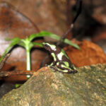
Dart frog
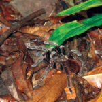
Tarantula
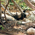
Boobies
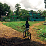
Arreti
Circumnavigation of Isla del Rey
Isla del Rey lies in the southern part of the Las Perlas and is the largest island in the group. We were keen to look for a mysterious submarine purportedly stranded on one of the outlying islands and decided a circumnavigation was in order. The wind was light on the first day of our grand adventure, but we were not in a rush and had planned to make a number of stops before arriving at our ultimate destination anyway.
The west coast of Isla del Rey is shoaled with virtually nowhere to anchor. So the first night we dropped the pick at Isla Pedro Gonzalez on the other side of Bahia del Rey, anchoring in the northern bay in front of a pretty village of brightly painted houses and a beach cluttered with pangas. The next day we motorsailed farther south and picked up a mooring at Hacienda del Mar, a resort on the remote Isla San Jose that welcomes yachties. Hacienda del Mar is also home to a flock of yellow and blue macaws, and we enjoyed watching them flying overhead, screeching and squawking as we sipped chilled white wine in the resort’s infinity pool.
After that, the wind finally picked up from the southwest, and we had a glorious beam reach on the 12-mile passage from Isla San Jose to Punta Cocos at the southern tip of Isla del Rey. As the southerly swell crashed against the rocky coastline we gave the point a wide berth and then had a rolly run-up to Isla San Telmo. Finally, we dropped the pick off a small beach on the north coast where we were sheltered from the swell, but assaulted by the pungent smell of guano—another “bird” island.
The morning after that we sipped coffee in the cockpit while keeping an eye on the shore, whereas the tide slowly dropped, the encrusted wreck of the submarine appeared on the beach. The Sub Marine Explorer, as it is called, was built in New York in 1865 and shipped to Panama to collect oysters and pearls for the Pacific Pearl Company. The submarine was abandoned in 1869 when the crew died from the bends. It is one of only five “diving machines” that have survived from that time. It’s amazing what you can find on the beach in Panama!
Darien
I’ve always been fascinated by Panama’s Darien region, with its vertiginous mountains, impenetrable rainforest, huge tracts of swampland, guerilla activity, drugs, gun-running and tropical diseases. Suffice it to say, it’s not for the faint of heart! Since 2013, however, military activity on both sides of the border has neutered the guerilla threat and tamped down the traffickers, so that tendrils of tourism have now begun to penetrate the area as well.
Many of the large rivers that drain Darien flow into the expansive Golfo San Miguel, which lies on the east side of the Gulf of Panama about 35 miles north the Isla del Rey. On the day we departed the latter, the wind was strong and gusty, and we flew along on starboard tack under a reefed mainsail and jib, easing sails as the wind veered until it was on the beam. Slaloming through a fleet of trawlers at the mouth the bay, we finally anchored just off Punta Garachine as the sun sunk low behind us to west.
Entering the Golfo San Miguel, and in the Darien’s many rivers, we would often use the flood tide to move upstream against strong outflowing currents. We sailed to Isla Iguana, for example, driven by the incoming tide and a light westerly breeze, and later enjoyed a sensational sunset tucked in on the island’s eastern side. The following day we continued upstream, passing through the narrow channel of La Boca accompanied by a trio of playful dolphins before arriving at our next destination, the small town of La Palma.
La Palma lies on a tight bend in the Rio Tuira where brightly colored buildings sprawl up the hillside, and houses on stilts lie clustered along the riverbank, their occupants’ pangas tied up in the water below. The single street has a bakery, a handful of shops and restaurants, and a motley collection of seedy looking bars. The road is not linked to the main highway but soon dies away to a dirt track on the outskirts of town.
While cruising in the uncharted waters of the Darien, we employed a combination of the hard-copy maps in our Panama Cruising Guide and the electronic terrain maps provided by Navionics to give us a rough idea of where we were. Although the rivers appear wide, the actual navigable channel can at times be quite narrow and tricky to follow, especially in the pouring rain with visibility at a minimum. Although our maps were useful, our own intuition and knowing how sandbanks tend to build up on the insides of bends and downstream from headlands and islands were the best guides.
Motoring 12 miles up the Rio Lara, we anchored behind a cluster of islands and continued on by dinghy to the village of Puerto Lara. The Wounaan people, the local indigenous group in this area, are skilled at carving and famed for their woven baskets. Sadly, though, we found none, either for sale or trade. The Wounaan’s traditional wooden huts are also fast being replaced by modern concrete buildings, and an asphalt road running through the village served as a vivid testament to the proximity to the Pan-American highway, just over five miles away. We visited the school and gave the students some pens and pencils. They gave us smiles in return.
The next day we explored a winding creek through a mangrove swamp to reach the remote village of Arreti. As we navigated the creek’s twists and turns the passage got smaller and shallower, to the point where we were just about to give up when we spotted a couple of dugout canoes tied up alongside a muddy bank ahead of us. We’d arrived. Arreti was a good deal more rustic than Puerto Lara, with wooden houses scattered along a dirt road. The people were welcoming and friendly and let us take away as many mangos as we could carry from the huge mango tree in the village square.

Of all the rivers we explored aboard Distant Drummer, Estero Gregorio Diaz was the smallest. At one point the channel was so narrow we couldn’t turn the boat around and were counting on the coming high tide to provide enough depth for us to reach a fork in the river where it would be wide enough to anchor. It was a hot, sunny day as we made our way upstream, and the humid air was still and silent in the mangroves as we languidly kept an eye out for crocodiles and blue herons fishing from low-hanging branches to either side.
Anchored back in La Palma a short while after that we had a rude awakening one morning. First, there was the sound of an outboard engine approaching. Then came a loud crack as a panga crashed into the side of Distant Drummer’s hull. Rushing up on deck, we found three bleary-eyed men looking a little startled. Apparently, they had been out fishing all night and had only just gotten back into internet range. They’d all been too busy checking their phones to see a large white yacht anchored in their path. Luckily the prow of the panga hit our rub rail, so there was no real damage. They, on the other hand, discovered the planking of their boat was now coming apart and headed quickly back to shore to make repairs.
The Western Side of the Gulf
Vista Mar marina, our stop after that, is located on the western side of the gulf and is popular with cruising yachts. It is a useful place to provision and top up on fuel and water, and is typically very social, with sundowners aboard neighboring boats, pot lucks, live music and karaoke evenings at the marina bar.
After finishing up our laundry and buying some supplies, we weighed anchor and had a glorious sail to Isla Taborcillo with a 15-knot northerly breeze on the port beam. Isla Taborcillo is little more than a sand bar in the shallow embayment of Bahia de Chame, and we’d timed our arrival to coincide with high tide, which allowed us to find a spot on the south side of the island where it was deep enough to anchor. At low tide, we were surrounded by a vast expanse of mudflats.
Years ago, the actor John Wayne was gifted Isla Taborcillo in recognition of his assistance in the negotiations that resulted in the handing over of control of the Panama Canal to the Panamanian government. He then used it as a holiday home until his death in 1979 after which it was bought by a Swiss publishing tycoon who created a wonderfully tacky Western-style resort in his memory. The buildings are now derelict, but it was fascinating to wander around the Duke’s Saloon, the Bridget Bardot suite and a Western “street” where guest rooms are disguised as the jail, the bank and the local sheriff’s office.
Leaving Isla Taborcillo under a bright blue sky with a gentle northerly breeze, we had a relaxing sail to Isla Taboga, where we anchored in the bay on the northeast side of the island and kayaked ashore to have a look around. The village of San Pedro, established by the Spanish in 1524, was built on the ruins of a pre-Columbian settlement, and history now lies buried beneath the community’s labyrinth of narrow streets. Stone axe heads, for example, are still found in the village’s garden, and a treasure trove of 1,000 pieces of silver was unearthed while building the village’s health clinic.
There are several hiking trails around the island. One day I was following a track through the rainforest behind the village and became so intrigued by the little green and black dart frogs hopping around in the undergrowth that I almost stepped on a tarantula. It gave me a horrible fright, but the old men in the village assured me that tarantulas are not dangerous. Still, I’m glad I missed it!
Ultimately, cruising in the Gulf of Panama was a fascinating experience. Indigenous peoples, conquistadors, pirates, pearl divers and movie stars have all lived there and left their mark on its sinuous shores. From a metropolitan marina to an uninhabited island, from a steamy rainforest river to a sun-baked beach, the Gulf of Panama has a place for every kind of cruiser to drop the hook and find contentment.
April 2020


