
 Photo courtesy of Bill Cook and CCA
Way back in 1610, Henry Hudson, commissioned by the Dutch East India Company to find a northwest passage to China, was the first Western navigator to discover the bay that now bears his name. During his exploratory voyage (1610-1611), Hudson and his crew spent a miserable winter locked in the ice after which his crew mutinied and set him and his son adrift in a rowboat in James Bay, at Hudson Bay’s southern end. It’s a part of history that’s long fascinated me.
Today, Hudson Bay is an almost forgotten sea as far as the nautical world is concerned. A handful of merchant ships supply the Cree and Inuit communities along its coasts from July to October. Cree and Inuit fishermen and hunters also occasionally move along the coast aboard their 24ft freighter canoes. But sailing for fun is considered to be more an expedition than a pleasure sail. According to our research, the last boats to cruise the east coast of Hudson Bay under sail were the trading schooners of the Révillon et Frères company, a fur trading outfit based in Paris, back in the 1930s.
Nonetheless, together with my sons Sam and Vincent, I decided to trailer O, my 1984 O’Day 222, the 600 miles from our home in Rouyn-Noranda, Quebec, to Chisasibi, on the shore of James Bay. From there we would sail her to Umiujaq on the eastern shore of Hudson Bay and back—a return voyage of nearly 600 miles.
Organizing the Journey

The expedition took us almost a year to plan. Covering 470,000 square miles, Hudson Bay is the second largest bay in the world, after the Bay of Bengal. The climate is subarctic—with the bay largely frozen over between September and mid-June—and even in summer the water temperature peaks in the mid-40s. With such limited water traffic, the only charts we could find were large-scale, with minimal bathymetric information about the coast. As a result, an important part of our planning was identifying safe harbors along our route (islands, deep bays and river estuaries) where we could shelter in bad weather.
To sail in James Bay and Hudson Bay, it is also essential to have a variable-draft sailboat, since shallow draft not only enables launching but navigation in the shallow waters found along much of the coast, particularly in river estuaries.
Knowing there would be no cell coverage in most of the area, we purchased an Inreach satellite communicator, which was to prove both invaluable and highly reliable. We paired it with a smartphone, which allowed us to send and receive e-mails and SMS, receive weather forecasts and even post messages on Facebook. The Inreach’s tracking function was especially nice as it allowed friends and family to follow our journey in real time, while the distress function would make it possible to call for help. For added security, we also rented a satellite phone.

Researching historical weather data, we found there would be an average of about one and a half days a week during which navigation could be difficult, either because of winds over 20 knots or the presence of fog. We, therefore, planned our itinerary to take into account these lost sailing days. As events proved, during our 17-day trip, we traveled between 40 and 60 miles a day and were weatherbound three days in all, which corresponded pretty well with our initial scheduling. We planned to anchor each night in protected inlets.
Given the three-week deadline for our expedition, we planned to motor into headwinds and motorsail whenever the wind did not allow us to reach a minimum speed of 3.5 knots under sail alone. To this end, we bought a new 6hp Tohatsu outboard, which proved reliable, economical and ultimately propelled us for about 37 percent of our 700-plus mile journey, in the process sipping only 18 gallons of fuel. Between the Tohatsu’s built-in alternator and a 20-watt solar panel, we installed on the sternrail, charging our various electronic devices (phone, Inreach, drone and laptop) was never a problem.
We did our cooking on the small alcohol stove in the galley and an outdoor gas grill. Preparing meals on the alcohol stove would also quickly heat the cabin up, something that was greatly appreciated during long days on the water. We kept our waste to a minimum by incinerating combustibles like plastic, paper and cardboard in a small metal box placed inside the barbecue.
Following the drive from Rouyn-Noranda, our odyssey began on July 23, 2017 at the Cree community of Chisasibi, where we launched O directly from the shore of the La Grande river, nine miles from James Bay.
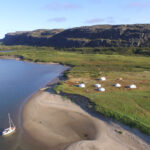
Anchored near an Inuit camp on the Little Whale River
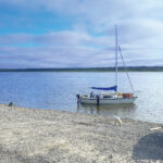
O stands ready shortly after her launch at the start of the expedition
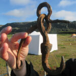
An artifact from the days of the Hudson Bay Company
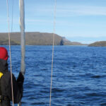
It was important to keep a sharp lookout: much of the bay remains poorly charted
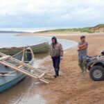
The Cree and Inuit typically use these kinds of 24ft freighter canoes to move up and down the coast
Underway
In addition to being quite shallow, the waters of James Bay are dotted with innumerable small, elongated islets composed mainly of rectangular rocks of contrasting colors in an arrangement of great beauty. Continuing on into Hudson Bay, though, we said farewell to these geographical features, which would not be seen again until we were 200 miles farther north, in the Umiujaq region.
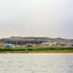
Four days later, we reached the community of Kuujjuarapik, or Whapmagoostui if you prefer. The community has two names because it is inhabited by both Cree and Inuit, and our brief stay there provided us an excellent opportunity to experience the vibrancy of a remote northern community during the short northern summer. There was, for example, lots of construction going on, and the air traffic was quite impressive for a community of just 700 inhabitants. The freighter Sarah Desgagne, typically moors directly offshore, delivering food, petroleum, building materials and anything else needed by the villagers.
Continuing on, we sailed past the Manitounuk Islands, a jewel in the Kuujjuarapik region. Stretching for nearly 40 miles, these islands delimit the Manitounuk Sound, protecting shipping (and us) from the open sea. After that it was back onto open water as we sailed along the empty coast, enjoying the solitude.
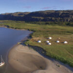
On the evening of July 28, we finally reached the mouth of the Goulet, a narrow stretch of water through a rocky canyon that connects Nastapoka Sound to Tasiujaq Lake, also known as Richmond Gulf, in Tursujuq Nunavik Park. The current runs strong through the Goulet, and you need to time your passage with the tide. The Goulet also offers an impressive entrance to the national park, a site of great beauty that in itself justified this expedition. Hudsonian cuestas—hills with a gentle slope on one side and a steep cliff on the other—reared to nearly 1,000 feet, providing unforgettable views. We have fond memories of our brief stay in Tursujuq Nunavik Park.
The next day, July 30, we weighed anchor at 0530 to head for Umiujaq, passing quickly through the Goulet with the help of a strong ebb current of about 6 knots. Strong headwinds greeted us as we returned to Hudson Bay, and we motored into the 20-knot northerly for several hours. We were grateful for the seakindliness of our little O’Day, which plugged into the nearly 3ft waves without complaint. The only time any of us felt seasick on the journey was when we were cooking underway.
A Change in Weather
With the northerly wind there was also a drop in temperature to nearly 50 degrees, so we decided to spend the night at the nearby harbor of Umiujaq instead of going directly to our original destination, Nastapoka Falls, 25 miles to the north. Umiujaq, which is Inuit for “resembles a boat,” is at the foot of a hill that actually does look like an upturned boat.
Later that night the weather forecast began calling for a strong windstorm lasting three to four days that was expected to arrive in the next 48 hours, prompting us to consider staying in a well-sheltered area to wait it out. At 0500 the next morning, our decision was made: we would head back south, giving up on going to the majestic Nastapoka Falls.
With 20 knots of wind on the beam, two reefs in the mainsail and the small jib up, we thoroughly enjoyed the 43-mile sail from Umiujaq to the mouth of the Little Whale River, where we arrived as planned at high water. As we made our way south we were captivated by the sublime beauty of the area, as the rugged coastline we sailed along was almost magically transformed itself into a surreal assemblage of fine sandy beaches and bare mountains, all softened in pastel hues.
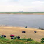
As luck would have it, an Inuit camp had sprung up on the sandy banks of the river here, and its inhabitants, unused to the sight of a small sailboat heading toward them, greeted us enthusiastically. It turned out the Inuit family here was from Umiujaq. They would camp there for two weeks, they said, the men fishing for whitefish during the day while the women cleaned the goose down used in the making of traditional parkas, much as they have done for hundreds of years. This almost surreal meeting in such a special environment will forever hold a unique place in our memory.
That evening, the promised windstorm arrived, and for three days and four nights, we were rocked by 20- and 30-knot winds. For the most part, we stayed in our tiny cabin, where we slept, read, ate and watched the many beluga whales that played in the water around us. Inside the cabin, we would sometime hear their songs as they approached the boat. Finally, on Wednesday, August 6, we began the long five-day return trip to Chisasibi. It was time to go home.
Reflections
Looking back on our adventure, we like to think that we were “explorers” in our own way. Having the opportunity to sail in a subarctic environment just two days’ drive from a major city is not only an exceptional situation but also a great opportunity. With minimal investment, marine tourism could easily begin on Hudson Bay. In Chisasibi, for example, the addition of a boat ramp and a floating dock on the La Grande River would help start expeditions on these northern seas.
Beyond the unique subarctic landscapes we experienced, we were also happy to have had the chance to meet some of the Cree and Inuit who are the natives of the area, to better know their environment and better understand their attachment to their culture and ancestral land. We were touched by both their kindness and the difficulties they have to deal with, living where they do. We now know a little better our “neighbors” in the north, and we dream of the day we can return.
Mining engineer and professor Jean Lelievre lives in Quebec and has been sailing his 22ft O’Day since 2011. See video of the expedition, titled Hudson Bay Sailing Expedition 2017 on YouTube.
All photos courtesy of Jean Lelievre
July 2019


